Yazoo Backwater Project
*** For the most recent reports on the Yazoo Backwater Project, please refer to our Media Page ***
*** You can now watch the 2019 Yazoo Backwater Flood podcast. ***
History
Following the Great Flood of 1927 Congress passed the Flood Control Act of 1928 which recognized that flooding due to the Mississippi River is a federal responsibility because 41% of the continental United States drains down the Mississippi River to the Gulf of Mexico,. This Act authorized the Mississippi River & Tributaries Project (MR&T) which called for levees and floodwalls, floodways, channel improvement and stabilization, and tributary basin improvements. In 1936, Congress recognized that some of the levee construction work cut off drainage outlets for interior basins, therefore Congress passed the Flood Control Act of 1936 which extends federal responsibility to many river basins that feed into the MS River, including the Yazoo Basin.
In 1941 the Congress, at the request of the Arkansas delegation, removed the Eudora Floodway from the MR&T Project. At the same time, the Mississippi delegation recognized that this action would result in higher stages on the Mississippi River at the mouth of the Yazoo River and cause flooding in areas previously safe from floods in the Mississippi Delta. The Flood Control Act of 1941 authorized the Yazoo Backwater Project to protect the Delta area of Mississippi from these increased stages. This project included a combination of levees, drainage structures and pumps.
The Yazoo-Mississippi Delta is bounded by the Mississippi River on the west side and by the bluff hills from just south of Memphis, TN through Greenwood to the Yazoo River. The Delta then follows the Yazoo River to it’s outfall into the Mississippi River just north of Vicksburg. The Delta is approximately 200 miles long and 60 miles wide.
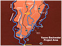
The Yazoo Backwater Area (the "South Delta") comprises approximately 1,550 square miles of alluvial valley in the lower Yazoo Basin of Mississippi. It encompasses the area south of the line between Hollandale and Belzoni, east of the Mainline Mississippi River Levee and west of the Yazoo River Levee.
Components of the Project
There are four major components of the Yazoo Backwater Project:
- Levees. The Yazoo Backwater Levee begins at the end of the Mainline Mississipi River Levee and proceeds upstream along the Yazoo River on the west bank to the West Guide Levee of the Will Whittington Auxiliary Channel near Spanish Fort, MS. During highwater, when overflow water from the Mississippi River backs-up the Yazoo River, the Yazoo Backwater Levee, along with the closed drainage structures, prevents the backwater from entering the South Delta. The Yazoo Backwater Levees were completed in 1978.
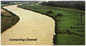
- Connecting Channel. The original Yazoo Backwater Project included drainage structures and pumps at the Little Sunflower River, Deer Creek and Steele Bayou. In order to be cost effective, the Connecting Channel was constructed and completed in 1978 to connect the Big and Little Sunflower Rivers, Deer Creek and Steele Bayou to bring water from 4093 sq. miles of the Delta to one point at the Steele Bayou Drainage Structure where one pumping plant can be constructed.
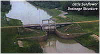
- Drainage Structures. These structures allow the Delta’s stormwater to pass through the open gates into the Mississippi/Yazoo River when stages on the riverside of the levee are lower than the stages on the interior basin. When the stage of the Mississippi/Yazoo River is higher than the stage on the interior basin, the gates are closed keeping flood waters from backing up into the South Delta. The Steele Bayou and Little Sunflower Drainage Structures were completed in 1969.
- Pumps.
 During highwater situations when the gates are closed on the drainage structures to keep out the MS River floodwaters, Pumps are needed to evacuate rainfall that occurs in the Delta and is trapped on the landside of the levee and drainage structures. The Pumps are the last remaining unconstructed feature of the Yazoo Backwater Project.
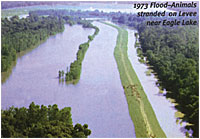
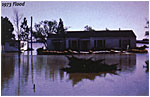
The Yazoo Backwater Project works flawlessly during MS River floods, as long as the Delta does not have any rainfall. In 1995, the Yazoo Backwater levees and drainage structures held out 8' of water that would have backed up into the South Delta. In 2011, the backwater levee and drainage structures held out 16.7' of water that would have backed up in the South Delta.
Legislation Delays Project
In March, 1986 the contract for the first item of work for the pumps was awarded. Actual construction began on May 5, 1986. The first item included the inlet channel and outlet channel for the pumps, and coffer dam construction around the pump site. Language drafted into the Water Resource Act of 1986 passed in October, 1986 stated that any project started after April 30, 1986 would be subject to cost sharing. This wording affected one project in the United States, the Yazoo Backwater Project. This was a change from the Federal responsibility that Congress had accepted in the previous Acts. Cost-sharing effectively killed the pump project because the Mississippi Levee Board and it’s tax paying citizens could not afford the cost-share. In 1996, Senator Thad Cochran added language to the Water Resources Development Act of 1996 that re-defined the start of construction as when the contract is awarded, thereby restoring full federal responsibility for the completion of the Yazoo Backwater Project.
Legislative Chronology
- March, 1986
- Pumps awarded to contract.
Senate passes WRDA of 1986 with an effective date of October 26, 1986. - May, 1986
- Dirt moving begins on Yazoo Pump Site (May 5).
House passes WRDA of 1986 with an effective date of May 15, 1986. - October, 1986
- House-Senate Conference agreement passes with grandfather date of April 30, 1986 for local cost-share.
Yazoo Backwater Project only project in U.S. adversely affected by conference agreement reaching outside scope of House (May 15) and Senate (October 26) effective dates. WRDA of 1996. - WRDA of 1996
- Provisions adopted to stipulate definition of physical construction to mean "date contract is awarded".
Language restores full federal responsibility for Yazoo Backwater project.
Forming A Consensus
In 1997, knowing that an attack was looming from the environmental community, the Corps of Engineers employed a professional facilitator and invited both flood control and environmental interests along with state and federal agencies, county supervisors and local land owners to a series of meetings in an attempt to reach an agreement for a project that would balance economics, flood control and environment interests. The facilitation resulted in a wide range of additional alternatives (over 30) for the Corps to evaluate, including structural (pump and levee), nonstructural alternatives and combinations of both.
In March, 1999 after meeting with the Deputy Regional Director of the U.S. Fish & Wildlife Service, the Mississippi Levee Board initiated a series of Consensus meetings with a large variety of organizations in an attempt to find a functional solution that would provide flood control with environmental benefits to the South Delta. Organizations that participated throughout the Consensus Building Process included:
| Corps of Engineers |
| County Officials |
| Delta Council |
| Delta Wildlife & Foresty |
| Ducks Unlimited |
| Environmental Protection Agency |
| Mississippi Department of Environmental Quality |
| Mississippi Department of Wildlife, Fisheries & Parks |
| Mississippi Levee Board |
| Natural Resource Conservation Service |
| South Delta Flood Control Committee |
| U.S. Fish & Wildlife |
| U.S. Forest Service. |
Five private environmental groups withdrew from the Consensus process after the first meeting:
Audubon Society
Gulf Restoration Network
Mississippi Wildlife Federation
National Wildlife Federation
Sierra Club.
Even though these five groups only attended the initial Consensus meeting, they were always invited and provided copies of the minutes of the meetings in an effort to keep them involved in the process.
During subsequent Consensus meetings, all organizations recognized the need to find a functional solution to provide flood protection to the residents of the South Delta. Extensive discussions (over 50 hours) took place regarding the benefits of operating a pumping plant with various start/stop elevations and the operation of the Steele Bayou gates to provide environmental benefits in managing higher low water levels in the South Delta area. Environmental agencies expressed a desire to work toward the reforestation of the lands below the 2-year flood event and a desire to restore wetland functions.
Plan Of Action

These processes helped the Corps refine the array of alternatives that would provide a combination of structural/nonstructural plans for flood protection and enhanced environmental resources for the South Delta. The structural components (pumps) will protect the higher lands, homes, roads, bridges and other infrastructure. The nonstructural components consist of easements and reforestation of crop land in the one-year flood plain to prevent damage on lands that would not be protected by the pumps.
In September, 2000 the Corps of Engineers released its Draft Reformulation Report and in November, 2007 the Corps released its final Reformulation Report. The final report recommends a 14,000 c.f.s. pumping plant which will be turned on/off at elevation 87 feet (the 1-year flood event in the South Delta). The Corps will offer reforestation easements to willing sellers on the 55,600 acres of developed land below 87 feet that will not receive any benefits from the pumps (be under water before the pumps are turned on). A change in the operation of the Steele Bayou Drainage Structure will increase the low water stages 1 to 3 feet in the channels.
This recommended plan will lower the 100 year flood elevation by 4.5 feet. Over 1,000 homes will be free of flooding from the 100-year flood. Terrestrial, aquatic and wetland resources habitat values will significantly increase. Connecting fragmented forests will improve habitat for endangered species and other wildlife. The availability of water during low-water conditions will increase by an additional 3'.
Where We Stand Now: Schedule and Budget
The last remaining feature of the Yazoo Backwater Project is the construction of pumps. The recommended plan is estimated to cost $220 million ($150 million for the structural features and $70 million for environmental non-structural features). It is estimated to take 4 years to complete this project.
Unfortunately, the Environmental Protection Agency (EPA) vetoed the Yazoo Backwater Project in 2008. Since 2008, if we had the pumps in place, they would have prevented $372 million in damages from 2008 to 2018. The pumps would have already paid for the entire project and would have a net gain of $152 million.
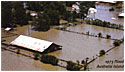
In 2018 the backwater reached 95.2' which flooded 450,000 acres including 170,000 acres of cropland.
In 2019 the backwater reached 98.2' which flooded 550,000 acres including 225,000 acres of cropland. This is the highest the backwater has ever gotten since the backwater levees were completed in 1978.
The Mississippi Levee Board is proud to be sponsoring the Yazoo Backwater Pump Project that will provide over-due flood protection to the South Delta while also providing many environmental benefits.
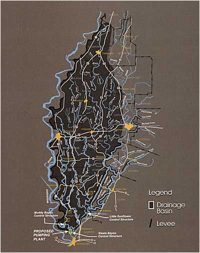
Drainage Area for the Yazoo Backwater Area
4093 Sq. Miles
2.62 Million Acres